Own Route (I combined Sections 1&2)
[GPX File]
Route Thoughts:
- Date: 2022.11.16
- Distance: 22.10km
- Time: 7:39 (04:52-12:31)
- Total Ascent/Descent: 1560m / 844m
- Calories: 3670 kcal
- Stayed at a friend’s place in 關渡, was worried that my fitness would be bad and would take too long, so started at 5:30am
- From 小油坑 you can take buses 1717 to mrt or 108 to 陽明山 central bus station
- Carried around 4 liters of water, drank around 3 liters, no water refill option at 二子坪
- Very muddy around 大屯山 with some rope sections
- I thought it was quite tiring, most tiring of all the sections I’ve hiked out of these trails.
Reference Information:
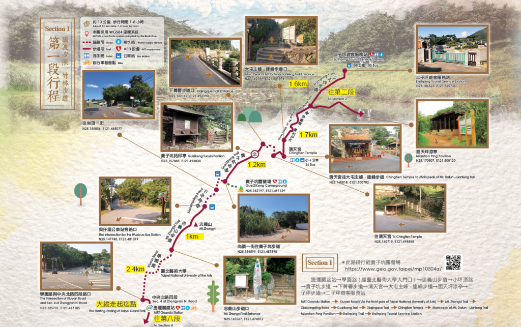
| Starting-Ending | MRT Guandu Station →Erziping Tourist Service Station |
|---|---|
| Planning | [Activity Pillar – 北] → Qingtian Temple → Miantianping → Erzhiping Tourist Service Station (N:25.152194, E:121.491029) ※Campground registration instructions. Go to Guizikeng Campground |
| Walking distance | About 13 km |
| Time | Take 7-8 hoursby foot |
| Characteristic of Trail | Sunset at Guandu Bamboo Forest Trail |
Reference GPX:
[GPX File]
Attractions:
Zhongyishan Hiking Trail 忠義山親山步道
Located at the rear mountain side of Taipei National University of the Arts, the trail is mostly made of stone steps. With dense shade, insects and birds chirping as well as over 90 percent of the trail being secluded, it is a primitive and quiet trail. After climbing to the top, you can see Guanyin Mountain and Tamsui River from afar. Some people say that Guanyin Mountain is the most beautiful when viewed from Zhongyishan.
坐落臺北藝術大學後山,多以石階為攀登路徑。林蔭密布,蟲鳴鳥叫,遮陽率達百分之九十以上,為原始幽靜之步道。登頂後,可遠望觀音山和淡水河。有人說從忠義山看觀音山,山形最美。
Guizikeng Geology 貴子坑地質
The upper layer is formed by igneous rocks erupted from the Tatun Volcano Group, while the lower layer is of sedimentary rocks – Wuzhishan stratum, which is the most ancient stratum in Taipei City, forming an unique and rare “unintegrated geological structure” and making it the best “outdoor geological classroom”.
上層為大屯火山群噴發而成火成岩,下層則為沉積岩-臺北市最古老的五指山地層,兩者形成特殊罕見的「不整合的地質構造」,可謂是最佳的戶外地質教室。
Miantianping 面天坪
The valley between Miantian Mountain and the western peak of Tatun Mountain, Miantianping, is a former settlement of the Tatun community of the Ke-tagal-an tribe, and the remains of which can still be seen today. The forest along the trail is primitive and quiet, of which the bamboo forest trail is the most renowned.
面天山與大屯山西峰間的谷地「面天坪」為昔日凱達格蘭族大屯社聚落,至今仍可見散落殘缺的遺址。沿途林相原始,古樸寧靜,其中又以竹林步道最著名。
Xiaqingque Trail 下青礐步道
With rich ecological resources and excellent views, the trail can be linked to the Guizikeng Trail to explore geographical and ecological marvels, as well as butterfly and bird watching, making it a comfortable parent-child trail for young and old ages alike.
生態資源豐富,視野極佳,可串聯貴子坑親山步道探索地質生態,再加上可進行賞蝶、賞鳥等自然觀察,為老少咸宜的舒適親子路線。
Leave a Reply