Own Route (I combined Sections 1&2)
[GPX File]
Route Thoughts:
- Date: 2022.11.16
- Distance: 22.10km
- Time: 7:39 (04:52-12:31)
- Total Ascent/Descent: 1560m / 844m
- Calories: 3670 kcal
- Stayed at a friend’s place in 關渡, was worried that my fitness would be bad and would take too long, so started at 5:30am
- From 小油坑 you can take buses 1717 to mrt or 108 to 陽明山 central bus station
- Carried around 4 liters of water, drank around 3 liters, no water refill option at 二子坪
- Very muddy around 大屯山 with some rope sections
- I thought it was quite tiring, most tiring of all the sections I’ve hiked out of these trails.
Reference Information:
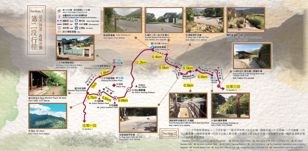
| Starting-Ending | MiantianpingPavilion→Xiaoyoukeng Tourist Service Station |
|---|---|
| Planning | Section route: (Erzhiping Tourist Service Station)→ Miantianping Pavilion → Tatun West Peak [Activity Pillar-走] → Tatun South Peak [Activity Pillar-縱] → Tatun Mountain Observation Platform [Activity Pillar-大] → Xiaoyoukeng Service Center |
| Walking distance | About 12Km (Accumulated 25 km) |
| time | Take 6-7 hours by foot |
| characteristic of Trail | Fire and flowers Dancing with butterflies |

Reference GPX:
[GPX File]
Attractions:
Erzhiping 二子坪
The trail is smooth with excellent scenery and is suitable for family tour. It is also known as the “Butterfly Corridor” because of the flat and open terrain and its rich butterfly and insect ecology. From May to July every year, more than 190 species of butterflies, including the blue-spotted butterfly, pink butterfly, and Papilio, can be seen flocking to the trail.
步道全程平坦,景觀優美,適合闔家同遊。又因其地勢平坦開闊,且擁有豐富的蝴蝶昆蟲生態,因此,有「蝴蝶花廊」的美稱。每年五至七月,可見青斑蝶、粉蝶、鳳蝶等多達190餘種彩蝶簇擁而至。
Bamboo Lake 竹子湖
Legend has it that in the early days, there were forests of arrow bamboos growing in this area, and the mountain breeze shook the forests as if they were lakes with ripples, hence the name Bamboo Lake. The lake is surrounded by several trails, where also two major events are held every year: the calla lily season (March-April) and the hydrangea season (May-June), which attracts many visitors every year to enjoy the flowers and take a stroll.
傳說早期此地簇生著箭竹林,山風搖動箭竹林的景象,彷彿是湖水盪漾,因此稱之為竹子湖。其周遭串聯數條步道,再加上每年度舉辦海芋季(3-4月)以及繡球花季(5-6月)兩大活動盛事,因此,年年吸引著眾多遊客前來賞花、漫步。
Tatun Mountain 大屯山
Tatun Mountain is a popular trail for hikers who are looking for consecutive hikes. The West Peak – South Peak section of the trail is steep and slippery, with a challenging cliff which requires the use of ropes to ascend and descend its treacherous course. The main trail consists of vertical and steep stone steps, flanked by manzanita and arrow bamboo forests. After climbing to the top, you can enjoy a wide view of the mountains, the best place to see a sea of clouds, the sunset, and enjoy a beautiful night view.
大屯山為連走的熱門路線,其中西峰-南峰路段山勢陡峭,土徑濕滑,需攀繩陡上陡下,具挑戰性。又,主峰步道由直峭陡上的石階組成,兩旁則是芒草與箭竹林。登頂後,視野開闊,可飽覽群山,為賞雲海、夕陽、夜景的最佳觀景點。
Leave a Reply