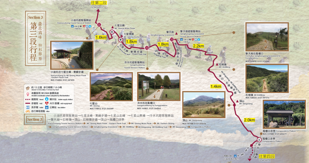
Own Route (I combined Sections 3&4)
[GPX File]
Route Thoughts:
- Date: 2022.12.03
- Distance: 22.3km
- Time: 6:14 (07:52-14:06)
- Total Ascent/Descent: 1020m / 1799m
- Calories: 2784 kcal
- Took 皇家客運 from between 北車 and 228 Park (25.04410, 121.51689) to 小油坑. Weekdays 6:40, weekends 7:00, advice is to arrive a minimum of 15-20 minutes early to get a seat
- Hiked in rain, changed socks once
- a lot of downhill, recommend trekking poles
- stone stairs to 冷水坑, then some dirt roads. muddy after 風櫃嘴
- view was pretty good, not too physically draining, just very long and very downhill
Reference Information:
| Starting-Ending | Xiaoyoukeng Tourist Service Station→Fonggueikou |
|---|---|
| Planning | Section route: Xiaoyoukeng Service Center → Main Peak of Qixing Mountain [Activity Pillar – 西] → East Peak of Qixing Mountain [Activity Pillar – 東] → Lengshuikeng Tourist Service Station → Qingtiangang Tourist Service Station → Fengguikou [Activity Pillar – 北] |
| Walking distance | About 13 km (Accumulated 38 km) |
| Time | Take 7-8 hoursby foot |
| Characteristic of Trail | Taipei summit Willow meadow |

Reference GPX:
[GPX File]
Attractions:
Qixing Mountain 七星山
The main peak is 1,120 meters high, making it the highest peak in Taipei City, where the erosion at the top of the mountain has formed seven hills of different sizes, just like the “seven stars” of the Big Dipper, hence the name. Due to the northeastern monsoon and the fact that the south of the mountain is sheltered, there is a rich variety of biodiversity in this place, while the north of the mountain is exposed to strong winds and is highlighted by a sea of white and yellow manzanita flowers in the fall. When a breeze blows, the majestic golden waves appear spectacularly, presenting a completely different natural landscape.
主峰高1120公尺,山頂因侵蝕而形成七個大小不一的山頭,猶如北斗「七星」般,因此得名,為臺北市最高峰。又因受東北季風影響,山南有山頭遮擋,具有豐富多樣性的生物;而山北則受強風吹拂,以秋天的白黃色芒草花海為亮點,當微風吹拂時,壯闊的金黃海浪甚是壯觀,兩者呈現全然不同的自然景觀。
Qingtiangang 擎天崗
The area is located in the middle of the Tatun volcano group and is a lava terrace formed by the overflowing of lava early on from the Zhugao Mountain to the north, and because of its calm and open terrain, it has been an important area for cattle grazing since the late Qing Dynasty and the Japanese administration. In addition, due to human and grazing influences, a grassland landscape dominated by carpet-like grass has been formed, and it has become a famous mango-viewing spot in autumn.
擎天崗位處大屯火山群峰的中央,是早期竹篙山熔岩向北噴溢所形成的熔岩階地,因地勢平緩開闊,自清末及日本治理時期以來便是牛隻放牧的重要場域。又,因人為與放牧影響,形成以類地毯草為主的草原景觀,也成為了秋季著名的賞芒景點。
Dingshan-Shihti Ling 頂山-石梯嶺
The trail is not very dynamic, but it offers a wide view and a rich variety of landscapes and ecology. For example, the uninterrupted mountain peaks, the dreamy and quiet willow forest, the green grassland, the golden azaleas that bloom in March and April on Dingshan, the Coupled Dipteris known as a “living fossil,” and the autumn and winter manzanita that sway in the wind, all display varying scenery throughout the seasons and are worth visiting.
步道全程起伏不大,卻可見遼闊視野以及豐富多樣的景觀、生態。如:一覽無遺的連綿山峰、夢幻幽靜的柳杉森林、青青草原、頂山三四月盛開的金毛杜鵑、有「活化石」之稱的雙扇蕨、迎風搖曳的秋冬芒草等,四季皆呈現不同風貌,值得不斷探訪。
Xiaoyuokeng Volcanic Terrain 小油坑火山地形
Xiaoyoukeng Tourist Service Station→FonggueikouThe most unique terrain in Yangmingshan National Park is the geothermal heat, hot springs, and vents. The most representative site is Xiaoyuokeng, a post-volcanic geological landscape with huge vents, sulfur crystals, and a spectacular collapsed terrain. From here, you can see the towering drops in the rock face with wisps of white smoke and a strong smell of sulfur pouring in. It is indeed a spectacular view.
陽明山國家公園最特殊的地形景觀在於地熱、溫泉及噴氣孔,其中最具代表性的據點,便是有著巨大噴氣孔、硫磺結晶、 壯闊崩塌地形的後火山活動地質景觀區–小油坑,在此可見高落差岩壁搭配縷縷白煙,以及濃厚硫磺氣味撲鼻而來,蔚為壯觀。
Leave a Reply