Own Route
[GPX File]
Route Thoughts:
- Date: 2022.11.19
- Distance: 12.0km
- Time: 3:21 (07:02-10:23)
- Total Ascent/Descent: 683m / 670m
- Calories: 1498 kcal
- Start at 捷運麟光站 and end by bus 270 that goes to 捷運南港站
- some dirt paths, not too many, mostly stone paved
- easy path, just some steep ascents and stairs, but second portion is very relaxing
Reference Information:
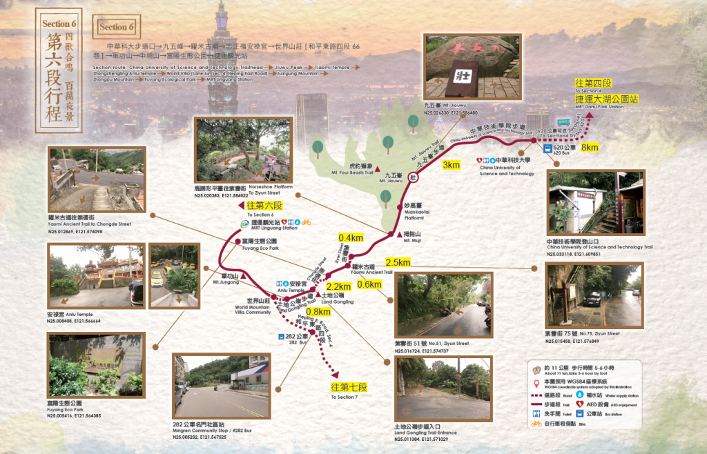
| Starting-Ending | (China University of Science and Technology) →(MRT Linguang Station) |
|---|---|
| Planning | Section route: China University of Science and Technology Trailhead → Jiuwu Peak[Active Pillar-壯] → Tiaomi temple → Zhongzhengling Anlu Temple → World Villa [Lane 66, Sec. 4, Heping East Road] → Juingung Mountain → Zhongpu Mountain → Fuyang Ecological Park → MRT Linguang Station |
| Walking distance | About 11 Km (Accumulated 79 km) |
| Time | Take 5-6hours by foot |
| (characteristic of Trail) | The four beasts sing together Million- dollar night view |
Reference GPX:
[GPX File]
Attractions:
Jiuwu Peak 九五峯
At 375 meters above sea level, it is the highest point in the Nangang Mountains. There is a boulder at the top of the peak with three inscriptions in red, “Jiuwu Peak”, named after General Yang Sen who climbed to the top at the age of 95 in 1976. In addition, the Jiuwu Boulder is an excellent viewpoint, offering a panoramic view of Taipei City and its surrounding mountains
海拔375公尺,為南港山系最高點。峰頂有一巨石上刻「九五峯」三個鮮紅大字,其因民國65年時,楊森將軍以95歲的高齡登頂命名。此外,九五巨石為一絕佳展望點,可將臺北市及四周群山景色盡收眼底。
Yongchunpi Wetland Park 永春陂濕地公園
Located in Xinyi District, it covers an area of about 4 hectares and is surrounded by elevated wooden trestles that connects to the trails of the Four Beasts Mountain, making it the first urban wetland park that combines environmental education, ecological restoration and historical value.
位在信義區四獸山下,占地約4公頃,周邊高架木棧道可以串連四獸山的步道系統,是兼具環境教育、生態復育及歷史價值的第一座都會型濕地生態公園。
Fuyang Ecological Park 富陽生態公園
The park has been converted from a military restricted area to a park, and because of its prolonged isolation from human interference and the government’s planning and design, the park is rich in forests, insects and birds, and retains natural resources such as low-altitude forests and streams that are rarely found in the urban area.
從軍事管制區轉為公園用地,因長久隔絕人為干擾,再加上政府規劃設計,因此,園內林相豐富、蟲鳴鳥叫,保留市區內難得一見的低海拔森林及溪流等自然資源,幾乎維持幾百多年前的生態景觀,成為都市中的自然樂園。
Four Beasts Mountain and Thumb Mountain 四獸山及拇指山
The Four Beasts Mountain are Tiger Mountain, Leopard Mountain, Lion Mountain and Elephant Mountain respectively, which are famous suburban mountains in Xinyi District of Taipei City. Following the ridges of Nangang Mountain, Thumb Mountain is reached, which is named after its resemblance to a thumb pointing towards the sky. After reaching the top, you can enjoy a 360 degree panoramic view of the Taipei Basin.
四獸山分別為虎山、豹山、獅山、象山,其為臺北市信義區著名的郊山,屬南港山系,因海拔不高、起伏不大,且展望視野佳,吸引許多人挑戰連走四座山。而沿南港山稜線行進,則可抵達拇指山,其狀似拇指擎天得名,登頂後,可見360零死角的臺北盆地廣闊視野。
Leave a Reply